
Walk an Ocala Street Address
An Ocala street directory search works best as a chain, not as a single hit. The Marion County Property Appraiser gives the current tax-roll starting point. Its site address identifies where the parcel lies, while its mailing address shows where tax notices go. Those may differ. The parcel identifier then carries the search into the county map and recorded deeds. Voter and old directory evidence can support residence, but neither creates a complete household list.
- Enter a short part of the address in the Marion County Property Search. Omit city, state, and ZIP, and copy the parcel number, site address, owner, and owner mailing address.
- Open the county GIS map and inspect every parcel along the segment. This catches vacant land that an assessor address result may omit.
- Use the parcel or legal description in the Clerk's Official Records search. Find the current acquisition deed and note its parties, book and page, and recording date.
- For a lawful street study, request the released voter extract rather than treating the individual status form as a reverse directory. Protected addresses and nonvoters will not appear.
- For an earlier household, check a criss-cross directory near the target year, then confirm the name in its alphabetic section and a census or deed.
The order prevents a common mistake: assigning the owner's mailing address to the property as an occupant. It also gives each later search a stable parcel or legal description when Ocala road forms vary.
Search Ocala Property Fields
The Property Appraiser accepts more than a full address. Address mode permits any portion, applies to improved parcels, and asks users to leave out city, state, and ZIP. Brief terms and a house number often work better than a long postal form. If the street directory result is weak, switch modes instead of forcing the address.
| Search choice | Entry rule | Best street use |
|---|---|---|
| Address | Any portion; omit city, state, ZIP | Find improved parcels by street |
| Name | Last name first | Check another parcel held by an owner |
| Parcel | Partial prefix; digits and dashes | Return to one mapped lot |
| OR book/page | Four digits for book or eight for book and page | Connect the parcel card to a deed |
| Subdivision | Starts-with search | Group lots under the same plat |
A parcel result can include owner names, site and mailing addresses, legal text, values, exemptions, sale history, and Official Records references. It is tax-roll information, not proof of occupancy or a legal survey.
The Marion parcel layer documents the fields behind the map:
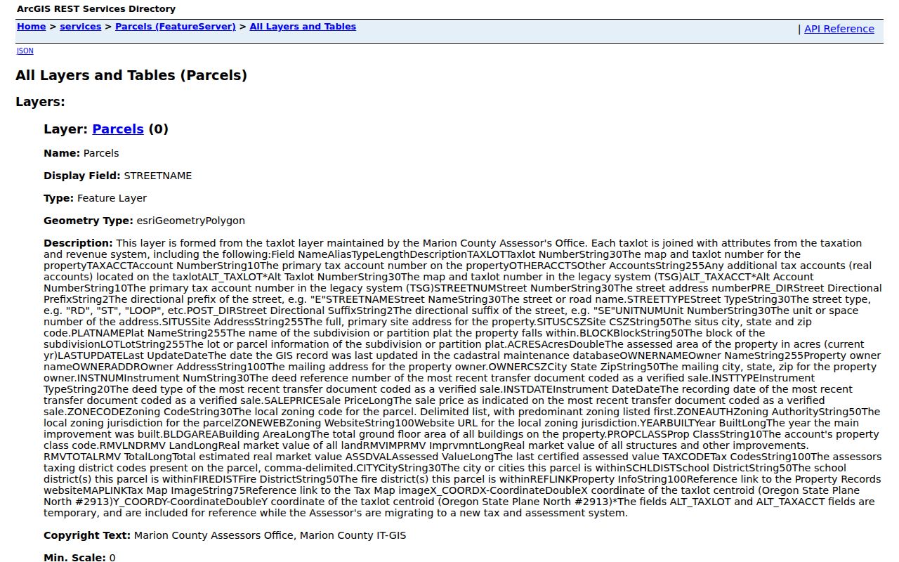
The layer helps distinguish the site address from owner mail and supplies the parcel key needed for the rest of the Ocala street directory chain.
Ocala Records Arranged by Address
No official source is a complete Ocala street directory. Each record answers a narrower question, so the strongest result comes from matching parcel geography with names and dated instruments.
| Record Set | Keeper | What It Shows | Access |
|---|---|---|---|
| Property roll | Property Appraiser | Owner, site, mail, parcel, values | Free portal |
| GIS parcels | Marion Growth Services | Every visible lot, subdivision, zoning | Free map |
| Deeds and liens | Marion County Clerk | Recorded parties and instruments | Web index, Record Center fallback |
| Voter extract | Florida Division of Elections | Lawfully released registration fields | Scheduled disk or pickup |
| Permit and code records | Ocala or Marion County | Work dates, roles, cases, liens | Jurisdiction dependent |
| Reverse directory | Library or archive | Listed householder by old address | Edition dependent |
The parcel number ties map, roll, deed, and many permit references together. The written street address connects sources that lack a parcel field. Keep dates beside every name, since an old deed party or permit applicant is not proof of a present resident.
Map Every Ocala Street Parcel
Address mode covers improved parcels, so it can leave a false gap where a vacant lot sits. The Marion County GIS Interactive Map fills that gap. Locate the address or parcel, zoom to the lot lines, use Identify, and click touching and across-street polygons one at a time. Record each parcel ID before opening its tax card.
GIS adds subdivision, plat, aerial, zoning, future land use, and district context. The service supports identify and query functions with a 5,000-record cap, but a public buffer control was not verified. Manual selection is therefore the reliable block method. Map lines are informational and are not a legal boundary survey.
- Parcel
- A land unit identified on the tax roll and GIS map.
- Situs address
- The physical location of the parcel, distinct from owner mail.
- Plat
- A recorded map dividing land into lots, blocks, roads, or rights of way.
- Criss-cross directory
- A historic directory arranged by street and house number.
Follow Ocala Deeds by Parcel
The Clerk portal does not offer a neat normalized street browse. Translate the street address into a parcel and legal description first. Then use Marion Official Records to find the present acquisition instrument. Search modes include party, document type, file number, book/page, case number, and parcel number.
Results show parties, document date, recording details, book/page, and related instruments. Anonymous online images are free where law permits display. Some restricted web images require the Clerk's registered-user service. For a street directory project, the index is the clue and the recorded page is the evidence.
General Official Records are dependable online from 1967. The Clerk also provides separate 1959 through 1964 historic books, while earlier material remains on microfilm. Ask staff about a record-specific cutoff because some coverage statements begin in 1965.
Note: Search the legal description when a spelling change or road form prevents the written address from matching an older instrument.
Decode Ocala Street Quadrants
Marion County 911 Management assigns road names and house or business numbers, then adds new addresses to dispatcher GIS. Ocala and Marion County addresses use NE, NW, SE, and SW prefixes. Straight roads tend to follow the grid. A road that bends across grid lines can take the predominant direction and be named from its higher-traffic end.
Compound forms such as SE 163rd Court Road can seem out of order. The Master Street Address Guide resolves that problem with the full prefix, street name, type, suffix, low and high ranges, community, and side code. 911 Management also offers address application, discrepancy, and quadrant-system forms.
For help with an official address, the office is at 2710 E Silver Springs Boulevard, Ocala, and is open weekdays from 8 a.m. to 5 p.m. The phone number is 352-671-8460. This is an addressing office, not a resident list.
Ocala Mail Is Not City Proof
An Ocala postal name extends well beyond the incorporated city. That geography decides where permits and code files live. County land, deed, court, and election systems cover both city and unincorporated parcels, while City of Ocala permit and code tools apply only within city limits.
Confirm the parcel, then compare it with the city boundary before choosing a custodian. The city ArcGIS districts service combines city limits, council districts, ZIP areas, and the Marion County boundary. A ZIP or postal city alone cannot settle jurisdiction.
This distinction matters along a long street that crosses a boundary. Two nearby addresses may need different permit searches even though both use Ocala in mail. Property and deed research still remains with Marion County.
Add Ocala Address Activity
Marion Civic Access now combines county permit and license applications, plan tracking, inspections, payments, address checks, and advanced property, case, and lien searches. Inside city limits, Ocala's permit reports may show permit number and type, work-site address, parcel, value, dates, status, subdivision, Official Records book/page, and named role blocks.
The City of Ocala Code Enforcement office also handles address-linked violations and liens. A case can name an owner or property, but it does not prove who occupied the site or who caused a violation. Liens may remain with the parcel until resolved.
Permit evidence dates work on a building. It should support, not replace, the ownership and residence parts of an Ocala street directory search.
Read Past Ocala Streets Carefully
A historic criss-cross directory can place a listed householder beside neighbors in address order. Choose an edition near the target date, locate the street and number sequence, copy the listed name, and then use the alphabetic entry for added detail. Census and deed records provide the next check. The full collection history belongs in the Ocala city directory.
Place labels can change even when a family stays put. Around 1880, Marti City stood between modern Pine Street and Martin Luther King Jr. Boulevard. It had its own government and as many as thirteen cigar factories before the industry shifted to Tampa. Search Marti City as an alternate place name and use cigar work only as a period clue.
No authoritative citywide renumbering date was found. Do not invent one. When an old number fails, compare plat, parcel, map, legal description, and adjacent names.
Limits of an Ocala Street Directory
Property records identify owners, not all residents. Renters, children, other household members, nonvoters, and people with protected addresses can be absent. A voter extract leaves out ballot choices and exempt fields. Driver records are constrained by federal and Florida law, and utility or delivery data is not a substitute for a public directory.
Historic sources have limits too. A directory lists only the people selected by its publisher, and an address section can omit boarders or members of a family. A deed proves a recorded land event, not who slept in the home. Use neutral wording such as “recorded owner” or “listed householder” unless another source supports residence.
Lawful use. Ocala address records are for lawful personal research, civic review, and family history. Never use them to stalk, harass, threaten, or harm anyone.
For older Official Records not online, submit a Record Center research request or visit the microfilm collection at 870 NW 4th Avenue. Copies are $1 per page, certification is $2 per document, and a name-and-year search is $2.